 |  |
Home HORAS !! Welcome.. Lissoi !! HORAS !! Welcome.. Lissoi !! |
|
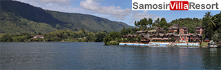
Samosir Island , in the middle of Lake Toba is the size of Singapore. Lake toba is the largest and deepest crater lake in world.906 meter above sea level, a water surface area of 1,265 square km, 90 km long with a coastline of 285 km, and with an average depth of 450 meters. Samosir island is the home of Batak people. The population of Samosir Island is approximately 130.568, or 91 per square kilometer .
The island measures 45 by 20 km, and originally was a peninsula. It only became a peninsula after the Dutch arrived and dug a canal across the small piece of land of 200 metres in 1906. This action seemed to have a lot to do among the local population, because they thought the island would slip away towards the middle of the lake and simply dissappear. The eastern coast of the island rises steeply from a small bank towards a central plateau with an altitude of 780 metres. This gradually descends towards the southern and western coast of the island and is scattered with small villages which dangerously lean against the rock, and cross ravains. The Samosir plateau mainly is clear rock, with some scattered forests, swamps and a small lake. There is a road parallel with the shores of the island, but this can be bad at certain points, with a number of bad bridges in the southwestern corner. From Pangururan, the kecamatan-centre at the western side, a bridge connects the island with mainland Sumatera. The road ascends to an altitude of 1800 metres after that. Here, the village of Tele offers a good view over the lake and the island. During the northeastern monsoon (September until January), a strong wind usually arrived from the high altitudes, the alogo bolong or 'big wind'. This produces waves of over one metre high, which can made traffic over water very hard. Local ferries, most of the time overloaded with freight and people, can be lost during these storms. Earlier the Batak used big tree-trunk canoos (solu) made of a single tree to cross the lake. Noaways only very small canoos are used. F.M. Schnitget, author of 'Forgotten Kingdoms in Sumatera', visited Samosir in the 1930's and described the adathouses, stone graves and coffins of no less than 26 villages. Looking for these villages is hard, because many of the names have been changed since them; others were abandoned and some of the stone sarcofagusses were removed from their original location. Outside the paved roads time and patience are an important factor to find the graves. But for many people a visit to Samosir is no more than a quiet ferry fare to Tomok, where the most famous of all Toba Bakat sarcofasussus are just on a few minutes away from the pier. Horas is the local greeting delivered with enthusiasm. The Batak people love their lake and island, and many traditional local songs are written about it. You are sure to hear some of these Batak songs on visit to Samosir island Lake Toba, singing is a strong part of the local culture walk past (or into) a toddy shop any evening after local men have consumed a few glasses of Tuak, or palm wine , and hear it for your self. Lissoi is their saying for cheers. There are also some fine woodcarvers on Samosir Island, as a glance at any of the souvenir shops will verify. |
